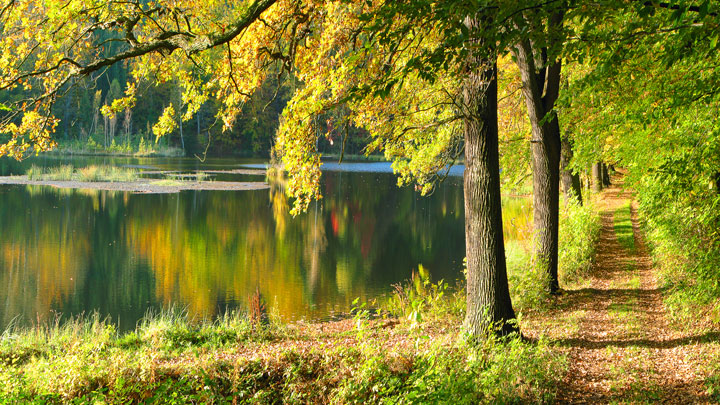
Dragon gorge

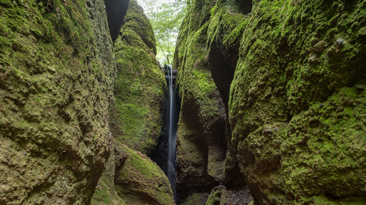
In the myth-enshrouded Dragon Gorge, south of Eisenach, romantics, nature fans and geologists all get their money’s worth. In the narrow ravine you can walk on planks over a roaring brook.

Thundering water under your feet, millions of sparkling droplets of water on mossy rocks whose clefts are not more than one metre apart – the Dragon Gorge is one of the most thrilling geological landmarks in Thuringia. Over millions of years the water of a brook has gouged itself almost ten metres deep into the red rocks below the Wartburg. Through the more than 200 metre ravine a path was built on which you can walk directly over the little brook through the phantastic rock formations.

Routing

Round walk Drachen- and Landgrafenschlucht:
Mariental – Drachenschlucht – Hohe Sonne – Weinstrasse – Großer Drachenstein – Landgrafenschlucht – Mariental

Dragon Gorge:
Mariental – Drachenschlucht – Hohe Sonne (turning to the Wartburg possible) or the other way round

Route information

Round walk Drachen- and Landgrafenschlucht:
Start/destination: B19, bus stop Mariental
Distance: approx. 6 km
Duration: approx. 3.5 hours
Trail mark: yellow square on white background,
Level of difficulty: easy to medium

Dragon Gorge:
Start: B19, bus stop Mariental or Hohe Sonne
Distance: 2.5 km
Duration: approx. 1.5 hours (uphill), approx. 1 hour (downhill)

Car parks: Mariental, Hohe Sonne
Bus: Route 11 and 31/ main station – Mariental – Hohe Sonne; Timetable: www.kvg-eisenach.de
Neither tour is suitable for bike, pushchair or wheelchair.
Note: For safety reasons, a short-term closure of the Dragon Gorge is possible after storm, heavy rain or black ice, throughout the year.
In case of doubt, please refer to
the Tourist-Information (+49 (0) 36 91 / 79 23 0)or to
the forestry commission office (+49 (0) 36 92 5 / 26 80 0)

drachenschlucht

rennsteig

Rennsteig

The first stage of the most famous German hiking trail starts in Hörschel. After about 15 km the hiker can reach Eisenach via the wildly romantic Dragon Gorge, or hike further on, to the Inselsberg.

Most famous hiking trail in Germany

From Eisenach, Rennsteig hikers reach Hörschel on the Werra by train or bus in a couple of minutes. They will now be accompanied on the border trail and commercial route, first mentioned in 1330, by the big “R” on the trees and historical signs. Wonderful hills and meadows, deep and silent forests and the constant view of the Wartburg make this hiking trip a real treat. After 15 km you can follow the “Hohe Sonne“ back to Eisenach or hike 33 km on to the Inselsberg.

Routing

Hörschel – Großer Eichelberg – Clausberg- Vachaer Stein – Hohe Sonne – Hohe Sonne – Ruhlaer Häuschen – Auerhahn – Großer Inselsberg – Grenzwiese …

Route information

Start: Hörschel
Destination: Blankenstein
Altitude: 196 – 942 m above MSL
Level of difficulty: medium
Distance: 168 km
Trail mark: white R

Stage 1:
Start: Hörschel
Destination: Hohe Sonne
Level of difficulty: medium
Distance: 14.6 km

Stage 2:
Start: Hohe Sonne
Destination: Grenzwiese
Level of difficulty: difficult
Distance: 19.3 km

Hainichlandweg

A jungle of dense, shady beech forests lies in the middle of the world heritage region Wartburg Hainich. Rare animals like wild cats, bats, woodpeckers and many more live in this diverse scenery.

With a length of 130 km, the Hainichlandweg entices you throughout the year with its marvellous ranges of hills, fertile meadows and colourful grassland. A large stand of early flowering plants, the stay in numerous resting places in summer, the play of colours in autumn and the visit to many of the tourist attractions in winter make the world heritage region Wartburg Hainich an all-season travel destination. Medieval cities, romantic towns with half-timbered houses, castles and palaces are waiting to be conquered. Train stations in the surrounding cities ensure a good accessibility.

Routing

1st stage: Weberstedt – Kammerforst, Hainich-Haus 15 km.
2nd stage: Hainich-Haus – Struth 20 km.
3rd stage: Struth – Heyerode, Alter Bahnhof 22 km.
4th stage: Heyerode, Alter Bahnhof – Probstei Zella 14 km.
5th stage: Probstei Zella – Mihla 21 km.
6th stage: Mihla – Hütscheroda 17 km.
7th stage: Hütscheroda – Weberstedt 21 km.

Route information

Start/destination: Weberstedt
Distance: 130 km
Trail mark: multicoloured beech leave and red dot on white square
Level of difficulty: medium

haninich

brandenburg

Werra-castle-trail

The almost 500 km Werra-Burgen-Steig leads through three federal states. With its many castles high above the Werra riverside, and often immediately at Grünes Band, the historical hiking trail is unique in Germany.

The Werra-Burgen-Steig in the world heritage region leads from the UNESCO world heritage Wartburg via the Rennsteig to the Brandenburg, then on to the Creuzburg and Burg Normannstein near Treffurt. The Hainichlandweg and the Qualitätswanderweg (quality hiking trail) Leine–Werra are its companions. Imposing views, charming landscapes, castles, monasteries and palaces are found along the way or in its proximity. The Werra-Burgen-Steig is suitable for long and short distances at any time of the year. Art, culture, concerts and restaurants tempt hikers into the countryside.

Routing

Marktplatz (market place) Witzenhausen – Sulzberg – Forsthaus Wendershausen – Flachsbachtal – Rastplatz “Öhrchen” – Burg Ludwigstein – Werleshausen – Bornhagen – Ruine Hanstein – Hanstein – car park Rimbach – “Alte Burg” – Teufelkanzel – Hasenwinkel bei Fretterode – Schlierbachtal – Vatterode – Vatteröder Stein – Dietzenröder Stein – Asbacher Nase – Ruine Altenstein bei Asbach – “Grünes Band” – high plateau of Gobertmassiv – “Grenzeck” via Kella – “Kapelle! – Kella – towards Schwebda – Schlossberg (castle hill) with Ruine Greifenstein – Großtöpfer – Hülfensberg

Route information

Start: Witzenhausen
Destination: Hildebrandshausen
Distance: 46 km
Duration: 13.5 h
Trail mark: consistent x 5 in white colour
Level of difficulty: medium

Luther trail

The Lutherweg connects at a length of over 800 kilometres the most important Luther places in Thuringia. In the area around the Wartburg there are Luther’s roots and numerous life stages.

Varied routes, phantastic sceneries and breathtaking views – the Wartburg region is a paradise for hikers. In the tracks of Luther, hikers and pilgrims are invited to discover an abundant cultural and natural landscape. The Luther trail leads from the Wartburg via Luther’s place of origin, Möhra, to Luthergrund near Steinbach. In the south you can hike the trail to Schmalkalden, and in the north to Mühlhausen.

Routing

Eisenach – Wartburg – Hohe Sonne – Wilhelmsthaler See – Etterwinden – Möhra Lutherdenkmal – Gumpelstadt – Schweina – Schloss Altenstein – Steinbach – Lutherdenkmal (Glasbachgrund)

Route information

Lutherweg from the Wartburg to Möhra – 18 km,
from Möhra to the Luther memorial – 16 km,
Start: Eisenach, Marktplatz (market place)
Destination: Lutherdenkmal (Glasbachgrund)(Luther memorial)
Distance: 31 km
Duration: 6 hours
Trail mark: green Fraktura-initial L on white background
Level of difficulty: easy to medium

luther

Jetzt buchen!